
Critical Habitat of the Lake Chubsucker (Erimyzon sucetta) Order (SOR/2018-156)
Full Document:
- HTMLFull Document: Critical Habitat of the Lake Chubsucker (Erimyzon sucetta) Order (Accessibility Buttons available) |
- XMLFull Document: Critical Habitat of the Lake Chubsucker (Erimyzon sucetta) Order [20 KB] |
- PDFFull Document: Critical Habitat of the Lake Chubsucker (Erimyzon sucetta) Order [12243 KB]
Regulations are current to 2026-05-26
Table of Contents
Critical Habitat of the Lake Chubsucker (Erimyzon sucetta) Order
SOR/2018-156
Registration 2018-07-06
Critical Habitat of the Lake Chubsucker (Erimyzon sucetta) Order
Whereas the Lake Chubsucker (Erimyzon sucetta) is a wildlife species that is listed as an endangered species in Part 2 of Schedule 1 to the Species at Risk ActFootnote a;
Return to footnote aS.C. 2002, c. 29
Whereas the recovery strategy that identified the critical habitat of that species has been included in the Species at Risk Public Registry;
Whereas a portion of the critical habitat of that species is in a place referred to in subsection 58(2)Footnote b of that Act and, under subsection 58(5) of that Act, that portion must be excluded from the annexed Order;
Return to footnote bS.C. 2015, c. 10, s. 60
Whereas, pursuant to subsection 58(5) of that Act, the Minister of Fisheries and Oceans has consulted with the Minister responsible for the Parks Canada Agency, namely the Minister of the Environment, with respect to the annexed Order;
And whereas the Minister of Fisheries and Oceans is of the opinion that the annexed Order would affect a reserve or any other lands that are set apart for the use and benefit of a band and, pursuant to subsection 58(7) of that Act, has consulted with the Minister of Indian Affairs and Northern Development and the band with respect to the Order;
Therefore, the Minister of Fisheries and Oceans, pursuant to subsections 58(4) and (5) of the Species at Risk ActFootnote a, makes the annexed Critical Habitat of the Lake Chubsucker (Erimyzon sucetta) Order.
Ottawa, July 3, 2018
Le ministre des Pêches et des Océans,  Dominic LeBlanc Minister of Fisheries and Oceans |
Marginal note:Application
1 Subsection 58(1) of the Species at Risk Act applies to the critical habitat of the Lake Chubsucker (Erimyzon sucetta) — which is identified in the recovery strategy for that species that is included in the Species at Risk Public Registry — other than the portion of that critical habitat that is in a place referred to in subsection 58(2) of that Act, more specifically, in Point Pelee National Park of Canada as described in Part 5 of Schedule 1 to the Canada National Parks Act and in Big Creek National Wildlife Area, Long Point National Wildlife Area and St. Clair National Wildlife Area as described in Part IV of Schedule I to the Wildlife Area Regulations.
Marginal note:Critical habitat
2 (1) For greater certainty, section 1 applies to that species’ critical habitat that is contained within the following areas:
(a) the entire Old Ausable Channel, Ontario, from the mouth of the channel (latitude 43°18′35.560″ N, longitude 81°45′47.797″ W) to its end at Grand Bend (latitude 43°13′57.309″ N, longitude 81°52′37.392″ W), as illustrated in Map 1 of the schedule;
(b) all contiguous waters and wetlands of L Lake, Ontario, including the northern and western tips of that lake where it is bisected by Outer Drive and the seasonal wetlands to the north of that lake, within the area set out in Table 1 of the schedule in respect of that lake, as illustrated in Map 2 of the schedule;
(c) the contiguous waters and wetlands of Rondeau Bay, Ontario, within the area set out in Table 1 of the schedule in respect of that bay, as illustrated in Map 3 of the schedule;
(d) the contiguous waters and wetlands of Long Point Bay, Ontario, including the ponds along the spit that forms the southern boundary of that bay, within the area set out in Table 1 of the schedule in respect of that bay, as illustrated in Map 4 of the schedule, but excluding the portion of that critical habitat that is in the Long Point National Wildlife Area; and
(e) all contiguous waters and wetlands of Lyons Creek, Ontario, from the Welland Canal (latitude 42°58′29.038″ N, longitude 79°13′12.175″ W) to Montrose Road (latitude 43°00′19.797″ N, longitude 79°07′25.073″ W), as illustrated in Map 5 of the schedule.
Marginal note:Features and attributes
(2) The critical habitat of the species includes the key features and attributes set out in columns 3 and 4 of Table 2 of the schedule.
Marginal note:Coming into force
3 This Order comes into force on the day on which it is registered.
SCHEDULE(Section 2)
TABLE 1
Coordinates of the Areas Within Which the Critical Habitat of the Lake Chubsucker is Found
| Column 1 | Column 2 | Column 3 | Column 4 | Column 5 | |
|---|---|---|---|---|---|
| Item | Location | Point 1 (NW) | Point 2 (NE) | Point 3 (SE) | Point 4 (SW) |
| 1 | L Lake | Latitude 43°13′27.490″ N, longitude 81°55′17.517″ W | Latitude 43°13′40.029″ N, longitude 81°54′29.740″ W | Latitude 43°13′24.085″ N, longitude 81°54′20.904″ W | |
| 2 | Rondeau Bay | Latitude 42°16′58.396″ N, longitude 81°53′50.301″ W | Latitude 42°19′34.763″ N, longitude 81°51′19.993″ W | Latitude 42°19′32.256″ N, longitude 81°50′42.122″ W | Latitude 42°16′03.673″ N, longitude 81°52′40.250″ W |
| 3 | Long Point Bay | Latitude 42°40′45.822″ N, longitude 80°19′57.794″ W | Latitude 42°33′04.619″ N, longitude 80°02′20.594″ W | Latitude 42°34′43.393″ N, longitude 80°26′24.629″ W | Latitude 42°36′36.151″ N, longitude 80°27′31.869″ W |
MAPS
Map 1: Critical Habitat of the Lake Chubsucker Within the Old Ausable Channel

Map 2: Critical Habitat of the Lake Chubsucker in L Lake

Map 3: Critical Habitat of the Lake Chubsucker in Rondeau Bay

Map 4: Critical Habitat of the Lake Chubsucker in Long Point Bay

Map 5: Critical Habitat of the Lake Chubsucker in Lyons Creek
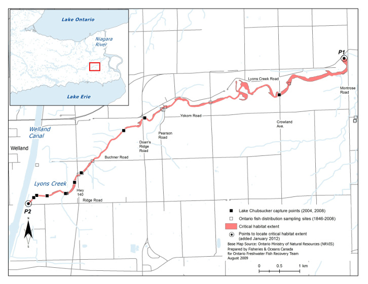
TABLE 2
Key Features and Attributes of Critical Habitat
| Column 1 | Column 2 | Column 3 | Column 4 |
|---|---|---|---|
| Life Stage | Function | Features | Attributes |
| Spawn to hatch | Spawning, cover, nursery | Areas that seasonally support aquatic vegetation |
|
| Young-of-the-year, juvenile, adult | Feeding, cover, nursery | Areas that seasonally support aquatic vegetation |
|
Page Details
- Date modified: