Critical Habitat of the Nooksack Dace (Rhinichthys cataractae ssp.) Order
Version of the schedule from 2016-05-02 to 2020-07-23:
![Map 1 is a map of the Bertrand Creek watershed in Township of Langley, British Columbia that indicates the locations of stream reaches that have been identified as critical habitat for Nooksack dace in the Recovery Strategy for the Nooksack dace in Canada (2008). In the identified reaches, critical habitat includes all aquatic habitats as well as riparian reserve strips of native vegetation on each side of the stream. The riparian reserve strips of native vegetation extend from the top of the bank on each side of the stream to the widths specified by the symbol used to identify the reach on the map. The coordinates for the start and end point of each critical habitat reach and the widths specified for the riparian reserve strips associated with each reach are listed in Table 1. Reaches on the map are labelled with codes that correspond to codes used to identify the reach in Table 1.](/images/SOR-2016-82img/SOR-2016-82_e001.jpg)
![Map 2 is a map of the Brunette River watershed in Burnaby, New Westminster and Coquitlam, British Columbia that indicates the locations of stream reaches that have been identified as critical habitat for Nooksack dace in the Recovery Strategy for the Nooksack dace in Canada (2008). In the identified reaches, critical habitat includes all aquatic habitats as well as riparian reserve strips of native vegetation on each side of the stream. The riparian reserve strips of native vegetation extend from the top of the bank on each side of the stream to the widths specified by the symbol used to identify the reach on the map. The coordinates for the start and end point of each critical habitat reach and the widths specified for the riparian reserve strips associated with each reach are listed in Table 1. Reaches on the map are labelled with codes that correspond to codes used to identify the reach in Table 1.](/images/SOR-2016-82img/SOR-2016-82_e002.jpg)
![Map 3 is a map of the Fishtrap Creek watershed in Abbotsford, British Columbia that indicates the locations of stream reaches that have been identified as critical habitat for Nooksack dace in the Recovery Strategy for the Nooksack dace in Canada (2008). In the identified reaches, critical habitat includes all aquatic habitats as well as riparian reserve strips of native vegetation on each side of the stream. The riparian reserve strips of native vegetation extend from the top of the bank on each side of the stream to the widths specified by the symbol used to identify the reach on the map. The coordinates for the start and end point of each critical habitat reach and the widths specified for the riparian reserve strips associated with each reach are listed in Table 1. Reaches on the map are labelled with codes that correspond to codes used to identify the reach in Table 1.](/images/SOR-2016-82img/SOR-2016-82_e003.jpg)
![Map 4 is a map of the Pepin Creek watershed in the Township of Langley and City of Abbotsford, British Columbia that indicates the locations of stream reaches that have been identified as critical habitat for Nooksack dace in the Recovery Strategy for the Nooksack dace in Canada (2008). In the identified reaches, critical habitat includes all aquatic habitats as well as riparian reserve strips of native vegetation on each side of the stream. The riparian reserve strips of native vegetation extend from the top of the bank on each side of the stream to the widths specified by the symbol used to identify the reach on the map. The coordinates for the start and end point of each critical habitat reach and the widths specified for the riparian reserve strips associated with each reach are listed in Table 1. Reaches on the map are labelled with codes that correspond to codes used to identify the reach in Table 1.](/images/SOR-2016-82img/SOR-2016-82_e004.jpg)
SCHEDULE(Section 2)
TABLE 1
Reaches Within the Watersheds and Riparian Reserve Strips that Constitute the Critical Habitat
Column 1 | Column 2 | Column 3 | Column 4 | Column 5 | Column 6 | |
---|---|---|---|---|---|---|
Item | Watershed | Reach CodeFootnote for TABLE 1 Reaches Within the Watersheds and Riparian Reserve Strips that Constitute the Critical Habitat1 | Reach Length (m) | Reach Start Point | Reach End Point | Width of Riparian Reserve Strip of Native Vegetation on Each Bank for Entire Reach Length (m) |
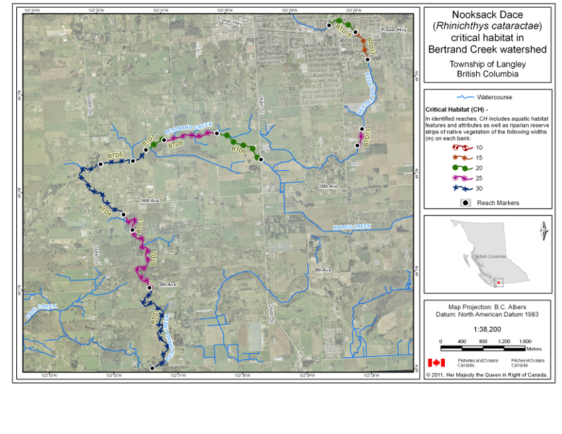
1 | Bertrand Creek | BTD1 | 2408 | latitude 49°00′07.96″ N, longitude 122°31′23.89″ W | latitude 49°00′57.54″ N, longitude 122°31′22.84″ W | 30 |
2 | Bertrand Creek | BTD2 | 1808 | latitude 49°00′57.54″ N, longitude 122°31′22.84″ W | latitude 49°01′33.71″ N, longitude 122°31′36.06″ W | 25 |
3 | Bertrand Creek | BTD3 | 579 | latitude 49°01′33.71″ N, longitude 122°31′36.06″ W | latitude 49°01′43.47″ N, longitude 122°31′43.65″ W | 25 |
4 | Bertrand Creek | BTD4 | 1844 | latitude 49°01′43.47″ N, longitude 122°31′43.79″ W | latitude 49°02′15.1″ N, longitude 122°32′02.71″ W | 30 |
5 | Bertrand Creek | BTD5 | 652 | latitude 49°02′15.1″ N, longitude 122°32′02.66″ W | latitude 49°02′16.13″ N, longitude 122°31′32.48″ W | 30 |
6 | Bertrand Creek | BTD6 | 351 | latitude 49°02′16.17″ N, longitude 122°31′32.57″ W | latitude 49°02′22.54″ N, longitude 122°31′19.8″ W | 30 |
7 | Bertrand Creek | BTD7 | 449 | latitude 49°02′22.54″ N, longitude 122°31′19.8″ W | latitude 49°02′28.15″ N, longitude 122°31′02.32″ W | 20 |
8 | Bertrand Creek | BTD8 | 1139 | latitude 49°02′28.15″ N, longitude 122°31′02.39″ W | latitude 49°02′30.62″ N, longitude 122°30′12,88″ W | 25 |
9 | Bertrand Creek | BTD9 | 1104 | latitude 49°02′30.64″ N, longitude 122°30′12.95″ W | latitude 49°02′13.19″ N, longitude 122°29′32.8″ W | 20 |
10 | Bertrand Creek | BTD13 | 356 | latitude 49°02′18.89″ N, longitude 122°28′02.9″ W | latitude 49°02′28.89″ N, longitude 122°27′57.39″ W | 25 |
11 | Bertrand Creek | BTD17 | 616 | latitude 49°03′11.45″ N, longitude 122°27′48.88″ W | latitude 49°03′28.69″ N, longitude 122°27′58.91″ W | 15 |
12 | Bertrand Creek | BTD18 | 637 | latitude 49°03′28.65″ N, longitude 122°27′59″ W | latitude 49°03′33.6″ N, longitude 122°28′23.27″ W | 20 |
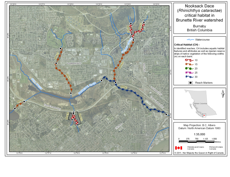
13 | Brunette River | BRN2 | 3702 | latitude 49°14′01.47″ N, longitude 122°52′48.62″ W | latitude 49°14′52.46″ N, longitude 122°55′00.98″ W | 30 |
14 | Brunette River | BRN5 | 517 | latitude 49°14′27.77″ N, longitude 122°57′45.31″ W | latitude 49°14′18.66″ N, longitude 122°58′05.36″ W | 15 |
15 | Brunette River | BRN16 | 1615 | latitude 49°14′36.82″ N, longitude 122°56′06.59″ W | latitude 49°15′19.07″ N, longitude 122°56′34.77″ W | 15 |
16 | Brunette River | BRN17 | 725 | latitude 49°15′19.07″ N, longitude 122°56′34.77″ W | latitude 49°15′39.14″ N, longitude 122°56′24.4″ W | 15 |
17 | Brunette River | BRN20 | 2362 | latitude 49°14′49.05″ N, longitude 122°54′31.94″ W | latitude 49°15′46.53″ N, longitude 122°53′50.68″ W | 15 |
18 | Brunette River | BRN21 | 1052 | latitude 49°15′46.52″ N, longitude 122°53′50.66″ W | latitude 49°16′10.32″ N, longitude 122°53′26.92″ W | 10 |
19 | Brunette River | BRN27 | 500 | latitude 49°15′54.63″ N, longitude 122°53′53.26″ W | latitude 49°16′09.6″ N, longitude 122°53′54.38″ W | 10 |
20 | Brunette River | BRN33 | 665 | latitude 49°14′10.05″ N, longitude 122°56′02.82″ W | latitude 49°13′52.55″ N, longitude 122°55′54.79″ W | 10 |
21 | Brunette River | BRN36 | 279 | latitude 49°14′08.29″ N, longitude 122°56′03.09″ W | latitude 49°13′59.85″ N, longitude 122°56′06.6″ W | 10 |
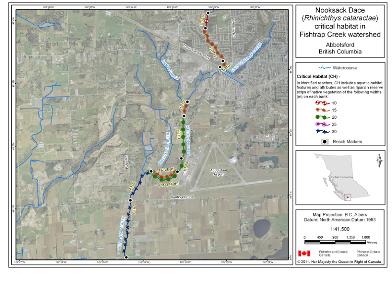
22 | Fishtrap Creek | FTP1 | 1984 | latitude 49°00′08.09″ N, longitude 122°24′24.82″ W | latitude 49°01′02.45″ N, longitude 49°01′02.45″ W | 30 |
23 | Fishtrap Creek | FTP2 | 1239 | latitude 49°01′02.63″ N, longitude 122°24′14.62″ W | latitude 49°01′29.22″ N, longitude 122°23′42.31″ W | 30 |
24 | Fishtrap Creek | FTP3 | 962 | latitude 49°01′29.15″ N, longitude 122°23′42.18″ W | latitude 49°01′27.53″ N, longitude 122°23′04.31″ W |
|
25 | Fishtrap Creek | FTP4 | 460 | latitude 49°01′27.56″ N, longitude 122°23′04.36″ W | latitude 49°01′40.21″ N, longitude 122°22′57.51″ W | 20 |
26 | Fishtrap Creek | FTP5 | 1300 | latitude 49°01′40.18″ N, longitude 122°22′57.51″ W | latitude 49°02′20.63″ N, longitude 122°22′50.49″ W | 20 |
27 | Fishtrap Creek | FTP6 | 458 | latitude 49°02′20.65″ N, longitude 122°22′50.35″ W | latitude 49°02′34.05″ N, longitude 122°22′44.6″ W | 15 |
28 | Fishtrap Creek | FTP10 | 282 | latitude 49°03′05.78″ N, longitude 122°21′54.74″ W | latitude 49°03′11.49″ N, longitude 122°21′50.08″ W | 15 |
29 | Fishtrap Creek | FTP11 | 1251 | latitude 49°03′11.49″ N, longitude 122°21′50.08″ W | latitude 49°03′43.72″ N, longitude 122°22′13.03″ W | 15 |
30 | Fishtrap Creek | FTP12 | 476 | latitude 49°03′43.7″ N, longitude 122°22′13.07″ W | latitude 49°03′58.17″ N, longitude 122°22′07.89″ W | 10 |
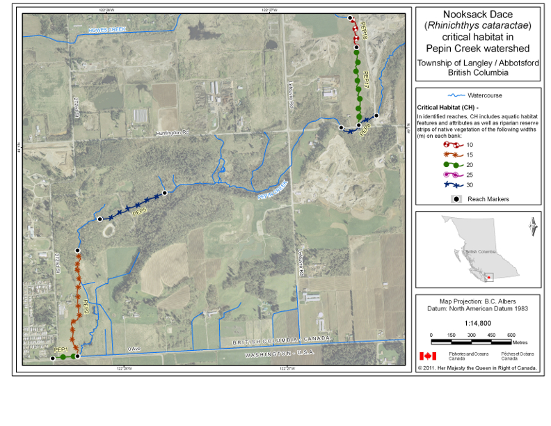
31 | Pepin Creek | PEP1 | 191 | latitude 49°00′08.34″ N, longitude 122°28′26.11″ W | latitude 49°00′08.57″ N, longitude 122°28′16.9″ W | 20 |
32 | Pepin Creek | PEP2 | 926 | latitude 49°00′08.57″ N, longitude 122°28′16.9″ W | latitude 49°00′34.25″ N, longitude 122°28′14.93″ W | 15 |
33 | Pepin Creek | PEP5 | 540 | latitude 49°00′41.61″ N, longitude 122°28′06.16″ W | latitude 49°00′47.19″ N, longitude 122°27′41.86″ W | 30 |
34 | Pepin Creek | PEP8 | 326 | latitude 49°01′00.9″ N, longitude 122°26′35.68″ W | latitude 49°01′03.37″ N, longitude 122°26′22.49″ W | 30 |
35 | Pepin Creek | PEP17 | 669 | latitude 49°01′01.29″ N, longitude 122°26′29.16″ W | latitude 49°01′20.22″ N, longitude 122°26′28.5″ W | 20 |
36 | Pepin Creek | PEP18 | 263 | latitude 49°01′20.22″ N, longitude 122°26′28.5″ W | latitude 49°01′27.43″ N, longitude 122°26′30.39″ W | 10 |
Return to footnote 1See maps.
Maps
Map 1: Critical Habitat — Bertrand Creek Watershed
![Map 1 is a map of the Bertrand Creek watershed in Township of Langley, British Columbia that indicates the locations of stream reaches that have been identified as critical habitat for Nooksack dace in the Recovery Strategy for the Nooksack dace in Canada (2008). In the identified reaches, critical habitat includes all aquatic habitats as well as riparian reserve strips of native vegetation on each side of the stream. The riparian reserve strips of native vegetation extend from the top of the bank on each side of the stream to the widths specified by the symbol used to identify the reach on the map. The coordinates for the start and end point of each critical habitat reach and the widths specified for the riparian reserve strips associated with each reach are listed in Table 1. Reaches on the map are labelled with codes that correspond to codes used to identify the reach in Table 1.](/images/SOR-2016-82img/SOR-2016-82_e001.jpg)
Map 2: Critical Habitat — Brunette River Watershed
![Map 2 is a map of the Brunette River watershed in Burnaby, New Westminster and Coquitlam, British Columbia that indicates the locations of stream reaches that have been identified as critical habitat for Nooksack dace in the Recovery Strategy for the Nooksack dace in Canada (2008). In the identified reaches, critical habitat includes all aquatic habitats as well as riparian reserve strips of native vegetation on each side of the stream. The riparian reserve strips of native vegetation extend from the top of the bank on each side of the stream to the widths specified by the symbol used to identify the reach on the map. The coordinates for the start and end point of each critical habitat reach and the widths specified for the riparian reserve strips associated with each reach are listed in Table 1. Reaches on the map are labelled with codes that correspond to codes used to identify the reach in Table 1.](/images/SOR-2016-82img/SOR-2016-82_e002.jpg)
Map 3: Critical Habitat — Fishtrap Creek Watershed
![Map 3 is a map of the Fishtrap Creek watershed in Abbotsford, British Columbia that indicates the locations of stream reaches that have been identified as critical habitat for Nooksack dace in the Recovery Strategy for the Nooksack dace in Canada (2008). In the identified reaches, critical habitat includes all aquatic habitats as well as riparian reserve strips of native vegetation on each side of the stream. The riparian reserve strips of native vegetation extend from the top of the bank on each side of the stream to the widths specified by the symbol used to identify the reach on the map. The coordinates for the start and end point of each critical habitat reach and the widths specified for the riparian reserve strips associated with each reach are listed in Table 1. Reaches on the map are labelled with codes that correspond to codes used to identify the reach in Table 1.](/images/SOR-2016-82img/SOR-2016-82_e003.jpg)
Map 4: Critical Habitat — Pepin Creek Watershed
![Map 4 is a map of the Pepin Creek watershed in the Township of Langley and City of Abbotsford, British Columbia that indicates the locations of stream reaches that have been identified as critical habitat for Nooksack dace in the Recovery Strategy for the Nooksack dace in Canada (2008). In the identified reaches, critical habitat includes all aquatic habitats as well as riparian reserve strips of native vegetation on each side of the stream. The riparian reserve strips of native vegetation extend from the top of the bank on each side of the stream to the widths specified by the symbol used to identify the reach on the map. The coordinates for the start and end point of each critical habitat reach and the widths specified for the riparian reserve strips associated with each reach are listed in Table 1. Reaches on the map are labelled with codes that correspond to codes used to identify the reach in Table 1.](/images/SOR-2016-82img/SOR-2016-82_e004.jpg)
TABLE 2
Key Features and Attributes of the Critical Habitat
Column 1 | Column 2 | Column 3 | Column 4 | Column 5 | |
---|---|---|---|---|---|
Item | Geographic Location | Life Stage | Function | Features | Attributes |
1 | Reaches within Bertrand Creek, Brunette River, Fishtrap Creek and Pepin Creek watersheds | Adult and juvenile | Spawning, nursery, rearing and feeding | Riparian habitat |
|
2 | Reaches within Bertrand Creek, Brunette River, Fishtrap Creek and Pepin Creek watersheds | Adult | Spawning (April – July) | Riffle habitat |
|
3 | Reaches within Bertrand Creek, Brunette River, Fishtrap Creek and Pepin Creek watersheds | Juvenile | Nursery and rearing | Shallow pool habitat |
|
4 | Reaches within Bertrand Creek, Brunette River, Fishtrap Creek and Pepin Creek watersheds | Juvenile | Feeding | Shallow pool habitat |
|
Adult and juvenile | Riffle habitat |
|
- Date modified: